
The parcel at 3518 Hillside Avenue covered 117 acres, and on June 16, 2014, it became city parkland for $3.5 million. It was the largest single piece of a buying program that Nanaimo council ran in less than a year in Linley Valley, the stretch of forest, rock bluffs and wetland between Departure Bay and Hammond Bay. In its May 2014 news release the city described the valley as holding "the largest amount of undeveloped land in Nanaimo." On the valley's western edge, between the new parkland and Rutherford Road, a neighbourhood called Linley Valley West was being built at the same time, and it needed a road.
Those two stories, the park and the subdivision, ran side by side for four years, and both were settled mostly by council votes recorded in city releases.
The 2003 park and the 2014 option agreements
The starting point was older. The city bought the 146-acre Linley Valley Cottle Lake Park in June 2003 in partnership with the Nanaimo Area Land Trust, according to the 2014 release. The park is reached from 3669 Rock City Road, and the city describes trails that pass through forest, valleys, fields and rocky knolls, with groomed paths and boardwalks on the city-managed part.
In March 2014, staff were told to secure purchase agreements on land to the west. At a closed meeting on May 5, 2014, council entered into option agreements on 221 acres, which barred the owners from selling to anyone but the city until the end of that year. The release listed five properties: 3518 Hillside Avenue, 5260 Tanya Drive (50 acres), 5600 Vanderneuk Road (41.7 acres), 3842 Stronach Avenue (8.7 acres) and 3651 Rock City Road (4.3 acres). It put the cost of buying and developing the park at about $9 million from reserve funds, and promised protection for "delicate rock bluffs, wetlands, fish bearing streams" along with new trails. Mayor John Ruttan said a park of more than 367 acres in the middle of the city would make Nanaimo "the envy of other communities."
The money still had to be found. The release said a report would go to council on May 26, 2014, proposing an amendment to the 2014-2018 Financial Plan so the purchases could proceed, and that council would be asked at its next two meetings to exercise the options.
A sixth parcel followed in June. The owner of 3650 Cottleview Drive agreed to transfer most of a six-acre lot for $1, in exchange for the city facilitating two building lots of 600 square metres each on Cottleview Drive.
What council actually bought
The final list in October 2014 was smaller than the one announced in May. On Oct. 20, council authorized the last two purchases, 5600 Vanderneuk Road and 3842 Stronach Avenue, for $2 million together. The city's tally: 177.5 acres of new parkland by the end of the month at a cost of $5.66 million. Ruttan called the program "one of this Council's key achievements during our term."
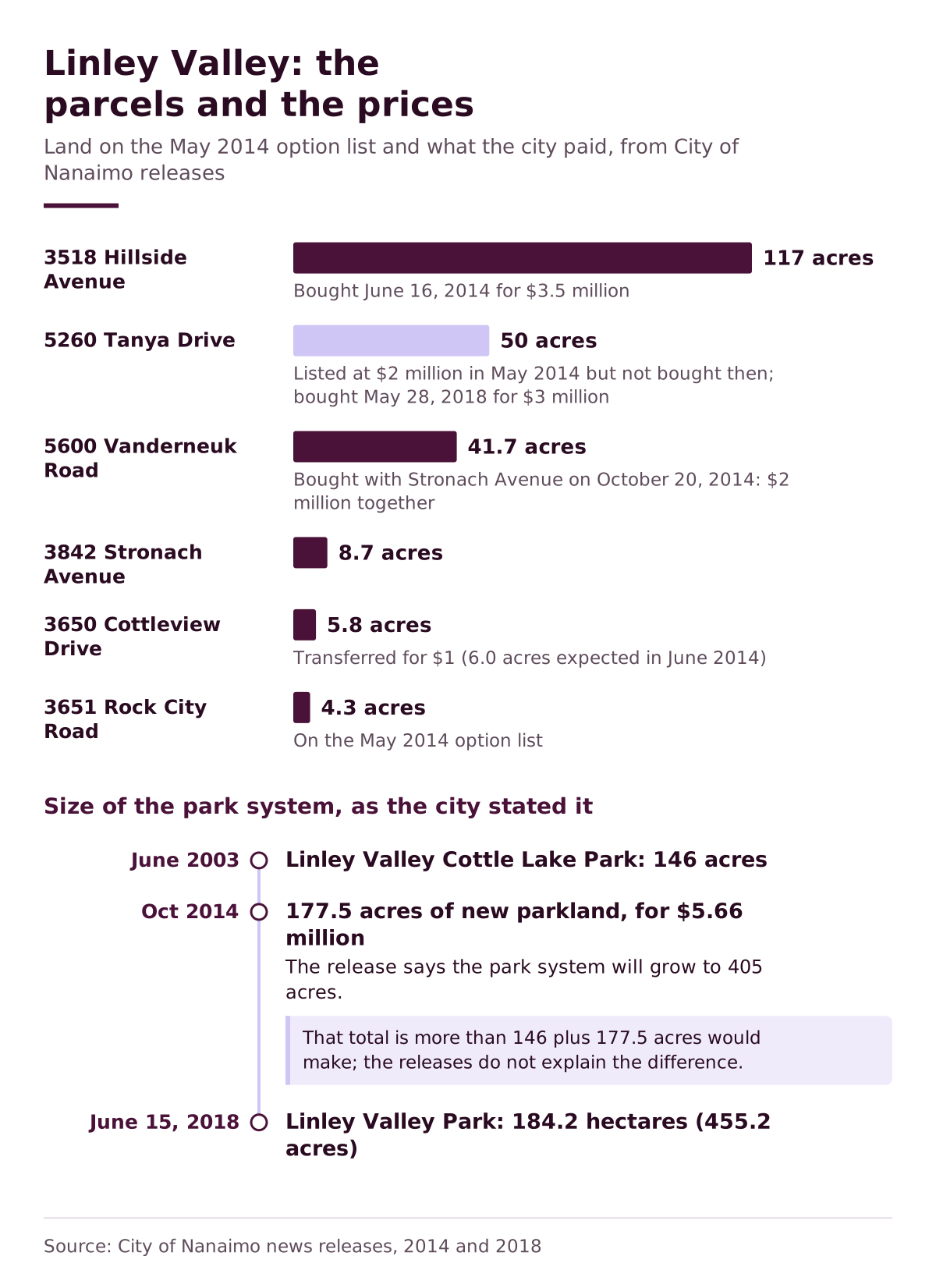
Set the two releases side by side and three things changed. Tanya Drive, the second-largest parcel on the May list, is missing from the October one. The Cottleview land came in at 5.8 acres rather than 6.0, and the city paid $30,000 in subdivision costs against the roughly $40,000 it had expected. And the totals do not quite reconcile: the October release says the Linley Valley park system would grow to 405 acres, more than the 146-acre Cottle Lake park plus 177.5 new acres would make. The releases do not explain the difference.
If you walk the valley with those parcel numbers in mind, the city's own warning makes more sense. Its park page says the land in Linley Valley is owned by several different groups, so anyone unfamiliar with the area should stay on the groomed trails. The city's park page has an interactive map and a downloadable KML file for the trail network, which is the nearest thing to an official Linley Valley trail map.
Linley Valley West and the road to Rutherford
While the park grew, the city was planning how people would get in and out of the new neighbourhood. In September 2015 it described Linley Valley West as "a new neighbourhood currently being developed in Linley Valley between Rutherford Road and the new Linley Valley Park," and said changes to land use, parks and transportation meant it needed a new multi-modal access plan.
There were two options. One was a new road linking Linley Valley Drive to Rutherford Road at Nelson Road. The other was to send traffic through existing streets to Rutherford at Vanderneuk Road and Brookwood Drive. The city held an open house at Oliver Woods Community Centre on Oct. 8, 2015, and kept an online survey open until Oct. 16. Director of community development Dale Lindsay said the evening had produced "some great feedback." The new connector road won.
In December 2015 council asked for detailed designs for a roundabout at Rutherford and Nelson. By June 2016 the functional design offered two ways to build the intersection, a multi-lane roundabout or traffic signals, each with "distinct functional and financial impacts," and the city asked for comments again. Either design, staff said, would handle current and future traffic, but they came with "different costs and challenges." Both versions included speed mitigation and a new multi-use trail along Rutherford Road, with possible traffic calming on Nelson Road. Council chose the roundabout in June 2016, to be phased, with street lighting, crosswalks, bicycle lanes and landscaping.
Construction in 2017
Tree clearing came first, scheduled to finish before March 15, 2017, ahead of the bird nesting season. Construction of the roundabout started on May 24, 2017. The intersection work was timed for the summer because of school traffic, and Nelson Road was closed at Rutherford for July and August. The city built it as a single-lane roundabout with space to expand to two lanes if traffic grows, and extended Linley Valley Drive to reach the new subdivision.
Project engineer Chris Lang warned in May that "lengthy delays should still be anticipated." By late October the city described it as a "challenging project" and scheduled the final layer of asphalt for Oct. 30 and 31, 2017, with line painting, signs and landscaping to follow.
The same north-end roads kept changing after that. In 2019 the city widened Hammond Bay Road between Prince John Way and Ricker's Curve, with slope stabilization, sidewalks and storm drain work. Project manager Michael Elliott said crews had been doing extra maintenance there since late 2012 just to keep the surface acceptable.
The Tanya Drive parcel returns
The open question from 2014 was answered four years later. On May 28, 2018, council approved buying 5260 Tanya Drive, a 50-acre parcel of second-growth forest next to the park, for $3 million. The release noted that the land had been the subject of a 2017 development application "not favoured by the public or Council," and that the city had been working with the owner for some time.
That was a million dollars more than the May 2014 price for the same 50 acres, which the city had listed at $2 million. Councillor Bill Yoachim put the purchase down to public pressure: "The people spoke stating the importance of keeping this space green." Councillor Ian Thorpe called the land "a magnificent addition to City green space," and Councillor Gord Fuller said it added "another layer of preservation to the complex ecosystem of Linley Valley." With the transfer on June 15, 2018, the city put Linley Valley Park at 184.2 hectares, or 455.2 acres. One line in that release refers to the parcel as 5250 Tanya Drive, which appears to be a typing error for 5260.
How the park is used, and who asked
Before the Tanya Drive deal closed, the city had already asked residents what they wanted from the land it owned. In the summer of 2017 it worked with Vancouver Island University's Mount Arrowsmith Biosphere Region Research Institute on a survey, focus groups and an Aug. 22 workshop at Oliver Woods, with students from the university's community planning program reporting back to parks staff. Parks planner Rob Lawrance said the results would show "how best to manage and improve the park" while respecting its sensitive areas.
Oliver Woods Community Centre, at 6000 Oliver Road, is the neighbourhood's civic room. Built to LEED standards, it has a preschool room, multipurpose rooms, a fitness studio and a twinned gym. The park beside it has had attention too: in April 2019 the city and Nanaimo NatureKids put up four wooden duck boxes for the wood ducks at Oliver Woods.
A year earlier the same partnership had hung maternity bat boxes at Diver Lake and at Linley Point Gyro Park, the neighbourhood park at 5784 Linley Valley Drive with large stormwater ponds, a playground, a sport court and a paved trail. Nanaimo's best-known wetland was not built for stormwater at all: the reclaimed floodplain at Buttertubs Marsh covers 55 hectares on the Millstone River.
Nanaimo's other big woods
For scale, Linley Valley's 184 hectares are smaller than Mount Benson Regional Park, which the Regional District of Nanaimo says covers 292 hectares on the mountain's upper north-east slopes and holds the headwaters of Witchcraft Lake, Westwood Lake and the Millstone and Chase rivers. The hike there from 2761 Benson View Road takes three to five hours return. Downstream, the Chase River fills the coal-era reservoirs of Colliery Dam Park, whose dams the city kept after a three-year argument.
What the city's releases never say is how much of Linley Valley remains in private hands. The park page's warning about land "owned by different groups" is the only hint, and it is still there.
Questions
Where is Linley Valley in Nanaimo?
Linley Valley lies in north Nanaimo between Departure Bay and Hammond Bay. The city lists the park address of Linley Valley Cottle Lake Park as 3669 Rock City Road, and the Linley Valley West neighbourhood sits on its western side, between the park and Rutherford Road.
How big is Linley Valley Park?
After the city bought 5260 Tanya Drive in June 2018, it put the park at 184.2 hectares, or 455.2 acres. The core of it, Linley Valley Cottle Lake Park, was bought in June 2003 in partnership with the Nanaimo Area Land Trust.
Is there a Linley Valley trail map?
The City of Nanaimo's park page for Linley Valley Cottle Lake Park includes an interactive map and a downloadable Google Earth (KML) file. The city warns that parcels in the valley belong to different owners, so visitors who do not know the area should keep to the groomed trails.
Can you swim in Cottle Lake?
The city's activity list for Linley Valley Cottle Lake Park names scenic viewing, jogging, picnicking, wildlife viewing and hiking, but not swimming. The park is listed as not wheelchair accessible.
What is at Linley Point Gyro Park?
Linley Point Gyro Park, at 5784 Linley Valley Drive, has natural areas, large stormwater pond systems, a playground, a sport court and a paved trail. In 2018 the city and Nanaimo NatureKids installed maternity bat boxes there and at Diver Lake.
Where is Oliver Woods Community Centre?
Oliver Woods Community Centre is at 6000 Oliver Road in north Nanaimo. It was built to LEED standards and has a preschool room, multipurpose rooms, a fitness studio and a twinned gymnasium, and it hosted the city's open houses on the Linley Valley West road access and the park's future.
Why is there a roundabout at Rutherford Road and Nelson Road?
It is the access road for Linley Valley West. After a 2015 consultation chose a new road from Linley Valley Drive to Rutherford Road at Nelson Road, council directed a phased roundabout in June 2016, built as a single lane with room for a second, and final paving was scheduled for October 30 and 31, 2017.
How much did Nanaimo pay for the Linley Valley parkland?
The parcels acquired in 2014 totalled 177.5 acres at a cost of $5.66 million, according to the city. In 2018 it paid $3 million for the 50-acre Tanya Drive property. The May 2014 announcement had estimated about $9 million, from reserve funds, for a larger 221-acre package.
Is Mount Benson part of Linley Valley?
No. Mount Benson Regional Park is a separate park, run by the Regional District of Nanaimo rather than the city. The regional district says the park covers 292 hectares on the mountain's upper north-east slopes, reached by the Benson View Regional Trail from 2761 Benson View Road.
What is the Downtown Nanaimo Business Improvement Area?
It is a downtown business association funded mostly by a levy on business and light industry properties inside its boundary. The city says the Downtown Nanaimo Business Improvement Area was re-established in 2026 under Bylaw 2025 No. 7395, through a joint process between the Downtown Nanaimo Business Association, downtown merchants and council.
Sources
- City Moves to Expand Linley Valley Park, City of Nanaimo, 2014-05-12
- City Adds Additional Parcel to Linley Valley Park, City of Nanaimo, 2014-06-02
- Council Completes Linley Valley Parkland Acquisitions, City of Nanaimo, 2014-10-21
- Linley Valley West - Neighbourhood Access Options Consultation, City of Nanaimo, 2015-09-30
- City seeking input on Linley Valley access, City of Nanaimo, 2015-10-14
- Public input sought for intersection upgrades at Rutherford and Nelson Roads, City of Nanaimo, 2016-06-08
- Work begins on Linley Valley West Access Project, City of Nanaimo, 2017-03-07
- Construction begins on Linley Valley West Access Project May 24, City of Nanaimo, 2017-05-23
- Have your say on the future of Linley Valley Park, City of Nanaimo, 2017-07-20
- Final Paving on Rutherford Roundabout, City of Nanaimo, 2017-10-26
- City of Nanaimo Set to Expand Linley Valley Park, City of Nanaimo, 2018-05-29
- Nesting Boxes Installed at Oliver Woods Park, City of Nanaimo, 2019-04-03
- Construction to begin on Hammond Bay Road widening project, City of Nanaimo, 2019-07-24
- Linley Valley Cottle Lake Park, City of Nanaimo
- Linley Point Gyro Park, City of Nanaimo
- Oliver Woods Community Centre, City of Nanaimo
- Oliver Woods Community Centre open house, City of Nanaimo, 2023-08-28
- Mount Benson Regional Park, Regional District of Nanaimo
- Business Improvement Areas, City of Nanaimo, 2026-01-26


